![](/images/other/stat-length.png)
![Randonnée Marche Gorges du Tarn Causses - Laval du Tarn (boucle) - Photo](https://media.geolcdn.com/t/1900/400/ext.pjpeg?maxdim=2&url=https%3A%2F%2Fservices.sitytrail.com%2FGeolivesWS%2FDownloadMedia.ashx%3FTrailID%3D1019167%26Media%3D20180809092152.jpg)
Laval du Tarn (boucle)
zoe.vienne
Utilisateur
![Longueur](/images/other/stat-length.png)
Longueur
11,5 km
![Altitude max](https://static1.geolcdn.com/siteimages/upload/files/1508320355ic_sort_altitude_max_24dp.png)
Altitude max
901 m
![Dénivelé positif](https://static1.geolcdn.com/siteimages/upload/files/1508320355ic_sort_den_pos_24dp.png)
Dénivelé positif
330 m
![Km-Effort](/images/other/stat-length.png)
Km-Effort
15,9 km
![Altitude min](https://static1.geolcdn.com/siteimages/upload/files/1508320355ic_sort_altitude_min_24dp.png)
Altitude min
785 m
![Dénivelé négatif](https://static1.geolcdn.com/siteimages/upload/files/1508320355ic_sort_den_neg_24dp.png)
Dénivelé négatif
331 m
![Boucle](https://static1.geolcdn.com/siteimages/upload/files/16400158638029165_repeat_loop_refresh_sync_direction_icon.png)
Boucle
Oui
Date de création :
2019-01-15 14:23:31.82
Dernière modification :
2019-01-15 14:23:31.82
![Marche](https://static1.geolcdn.com/sitytour/trail-icons/101.png)
2h48
Difficulté : Facile
![Scannez ce code QR pour ouvrir la randonnée dans l'application SityTrail](https://capi.geolives.com/qq0zvz2zws4bq2lad0pu/sitytour/trails/1019167/qr.png?size=200)
Application GPS de randonnée GRATUITE
À propos
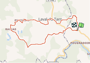
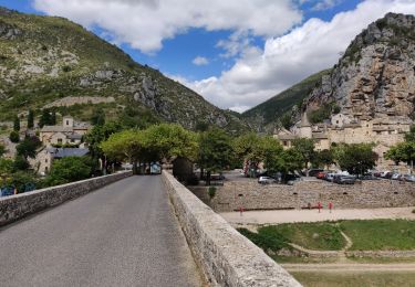
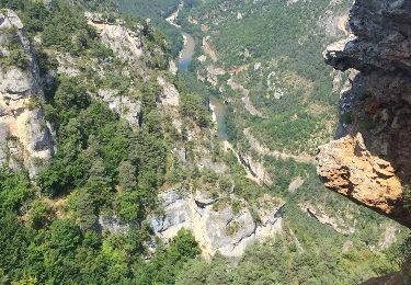
Randonnée Marche de 11,5 km à découvrir à Occitanie, Lozère, Gorges du Tarn Causses. Cette randonnée est proposée par zoe.vienne.
Description
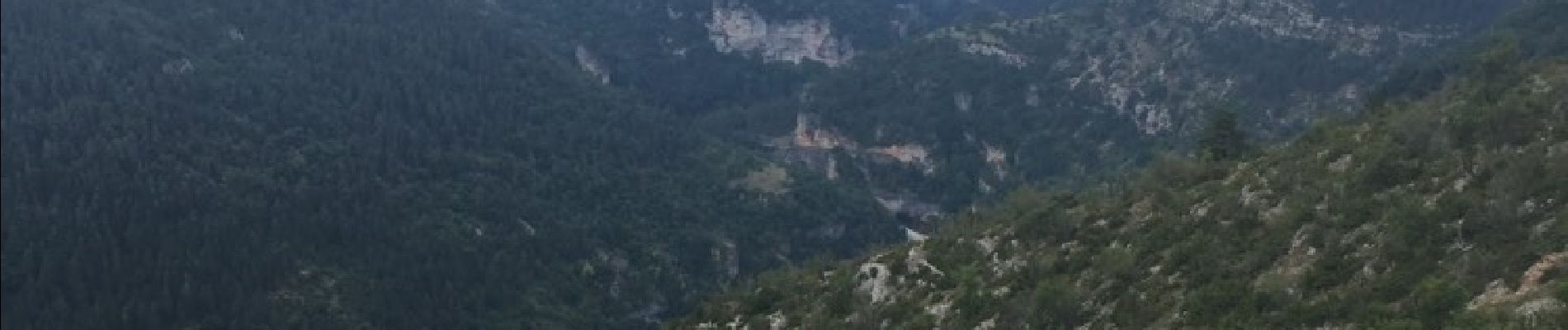
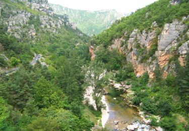
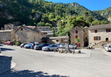
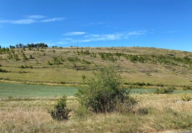
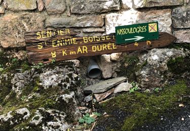
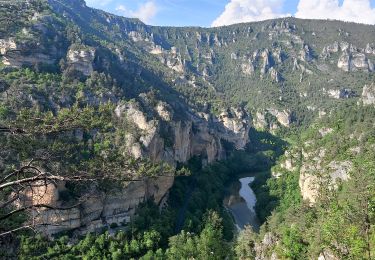
Randonnée faite le 9 août 2018, pas de difficulté particulière. Faire juste attention au départ de ne pas louper le petit chemin balisé bleu qui prend à angle droit sur la gauche de la route (sens Canourgue). Beaux paysages sur le Causse Sauveterre.
Localisation
Pays :
France
Région :
Occitanie
Département/Province :
Lozère
Commune :
Gorges du Tarn Causses
Localité :
Sainte-Enimie
Départ:(Dec)
Départ:(UTM)
529584 ; 4910598 (31T) N.
Commentaires
Randonnées à proximité
![Randonnée Marche Gorges du Tarn Causses - Sentier de St-Chély du Tarn - Photo](https://media.geolcdn.com/t/375/260/ext.jpg?maxdim=2&url=https%3A%2F%2Fservices.sitytrail.com%2FGeolivesWS%2FDownloadMedia.ashx%3FTrailID%3D111743%26Media%3D8149_6.jpg)
![Marche Marche](https://static1.geolcdn.com/sitytour/trail-icons/101.png)
Sentier de St-Chély du Tarn
Marche
Très difficile
(3)
Gorges du Tarn Causses,
Occitanie,
Lozère,
France
![](/images/other/stat-length.png)
15,8 km | 25 km-effort
4h 30min
![](https://static1.geolcdn.com/siteimages/upload/files/16400158638029165_repeat_loop_refresh_sync_direction_icon.png)
Oui
![Randonnée Marche Gorges du Tarn Causses - Saint Chely 17 km - Photo](https://media.geolcdn.com/t/375/260/fd8a2a6b-4459-4f35-901e-690e418ad6dc.jpg&format=jpg&maxdim=2)
![Marche Marche](https://static1.geolcdn.com/sitytour/trail-icons/101.png)
Saint Chely 17 km
Marche
Moyen
Gorges du Tarn Causses,
Occitanie,
Lozère,
France
![](/images/other/stat-length.png)
17,1 km | 27 km-effort
6h 7min
![](https://static1.geolcdn.com/siteimages/upload/files/16400158638029165_repeat_loop_refresh_sync_direction_icon.png)
Oui
![Randonnée Marche Mas-Saint-Chély - Mas St Chely Mont Servy 5 km - Photo](https://media.geolcdn.com/t/375/260/af00a001-80c4-4ac5-94a0-430ed07578bd.jpg&format=jpg&maxdim=2)
![Marche Marche](https://static1.geolcdn.com/sitytour/trail-icons/101.png)
Mas St Chely Mont Servy 5 km
Marche
Facile
Mas-Saint-Chély,
Occitanie,
Lozère,
France
![](/images/other/stat-length.png)
5,5 km | 7,8 km-effort
1h 38min
![](https://static1.geolcdn.com/siteimages/upload/files/16400158638029165_repeat_loop_refresh_sync_direction_icon.png)
Oui
![Randonnée Marche Gorges du Tarn Causses - ste enimie - la Malene - Photo](https://media.geolcdn.com/t/375/260/eb08616c-72b6-43fb-8af1-e2907fa3fc92.jpg&format=jpg&maxdim=2)
![Marche Marche](https://static1.geolcdn.com/sitytour/trail-icons/101.png)
ste enimie - la Malene
Marche
Facile
Gorges du Tarn Causses,
Occitanie,
Lozère,
France
![](/images/other/stat-length.png)
15,9 km | 22 km-effort
4h 36min
![](https://static1.geolcdn.com/siteimages/upload/files/16400158638029165_repeat_loop_refresh_sync_direction_icon.png)
Non
![Randonnée Marche Gorges du Tarn Causses - Ste Enimie, le Boisset - Photo](https://media.geolcdn.com/t/375/260/c8e7aa0f-2f81-400e-a6dd-e67c5f500e2c.jpg&format=jpg&maxdim=2)
![Marche Marche](https://static1.geolcdn.com/sitytour/trail-icons/101.png)
Ste Enimie, le Boisset
Marche
Moyen
Gorges du Tarn Causses,
Occitanie,
Lozère,
France
![](/images/other/stat-length.png)
8,4 km | 14,6 km-effort
2h 33min
![](https://static1.geolcdn.com/siteimages/upload/files/16400158638029165_repeat_loop_refresh_sync_direction_icon.png)
Oui
![Randonnée Marche Gorges du Tarn Causses - Au long du Tarn: de St Enimie aux Vignes - Photo](https://media.geolcdn.com/t/375/260/a97cde4c-beef-4feb-8a60-28696a762de5.jpg&format=jpg&maxdim=2)
![Marche Marche](https://static1.geolcdn.com/sitytour/trail-icons/101.png)
Au long du Tarn: de St Enimie aux Vignes
Marche
Très difficile
Gorges du Tarn Causses,
Occitanie,
Lozère,
France
![](/images/other/stat-length.png)
28 km | 39 km-effort
8h 54min
![](https://static1.geolcdn.com/siteimages/upload/files/16400158638029165_repeat_loop_refresh_sync_direction_icon.png)
Non
![Randonnée Marche Gorges du Tarn Causses - Tour du Causse Méjean - Etape 1 - Photo](https://media.geolcdn.com/t/375/260/ext.jpg?maxdim=2&url=https%3A%2F%2Fservices.sitytrail.com%2FGeolivesWS%2FDownloadMedia.ashx%3FTrailID%3D1037411%26Media%3Dfix__20180831135516.jpg)
![Marche Marche](https://static1.geolcdn.com/sitytour/trail-icons/101.png)
Tour du Causse Méjean - Etape 1
Marche
Facile
Gorges du Tarn Causses,
Occitanie,
Lozère,
France
![](/images/other/stat-length.png)
15,5 km | 22 km-effort
4h 36min
![](https://static1.geolcdn.com/siteimages/upload/files/16400158638029165_repeat_loop_refresh_sync_direction_icon.png)
Non
![Randonnée Marche Gorges du Tarn Causses - rando saint Charly du Tarn par le haut et retour par le bas - Photo](https://media.geolcdn.com/t/375/260/ext.jpg?maxdim=2&url=https%3A%2F%2Fservices.sitytrail.com%2FGeolivesWS%2FDownloadMedia.ashx%3FTrailID%3D1029620%26Media%3Dfix__20180827152528.jpg)
![Marche Marche](https://static1.geolcdn.com/sitytour/trail-icons/101.png)
rando saint Charly du Tarn par le haut et retour par le bas
Marche
Moyen
Gorges du Tarn Causses,
Occitanie,
Lozère,
France
![](/images/other/stat-length.png)
16,7 km | 26 km-effort
6h 3min
![](https://static1.geolcdn.com/siteimages/upload/files/16400158638029165_repeat_loop_refresh_sync_direction_icon.png)
Oui
![Randonnée Marche La Malène - La Malène roc de Serre rocher des hourtous - Photo](https://media.geolcdn.com/t/375/260/ext.jpg?maxdim=2&url=https%3A%2F%2Fservices.sitytrail.com%2FGeolivesWS%2FDownloadMedia.ashx%3FTrailID%3D1017972%26Media%3D20180807123217.jpg)
![Marche Marche](https://static1.geolcdn.com/sitytour/trail-icons/101.png)
La Malène roc de Serre rocher des hourtous
Marche
Facile
La Malène,
Occitanie,
Lozère,
France
![](/images/other/stat-length.png)
13,5 km | 21 km-effort
4h 11min
![](https://static1.geolcdn.com/siteimages/upload/files/16400158638029165_repeat_loop_refresh_sync_direction_icon.png)
Oui